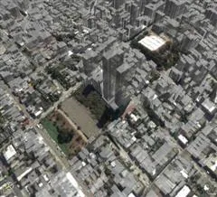
Finally, I crawled out of the hole and tried Google Earth. You will never look at maps the same way again. This thing is simply amazing. Wow! OK I just spent 1 hour looking at my city and took a 3-D virtual tour of the Grand Canyon. I stopped only because my machine froze. Perhaps it had to do with the amount of processing or graphics, or network usage. It’s like playing video games with our little planet Earth. The real power of the software is in layers. Just like a Photoshop document, you can stack up layers of map data in Google Earth. Some of the many layers offered are, National Geographic Magazine, Keyhole Community BBS, Businesses, Roads, Terrain, Buildings, Borders, Crime Stats, Postal Code Boundaries, 3D buildings, Earthquakes and Populated places. The Google Earth software is currently in beta and is offered in Free, Plus, and Pro formats for Windows based PCs with lots of RAM and 3D graphics cards. I would guess almost all people who bought or built a PC or laptop in the past two years are in good shape. So Google has now officially entered the business of selling software. Besides Toolbar, Desktop, and Talk there are a slew of other helper applications. While Microsoft is going online with Live, Google is going “soft”.